From terrorism to refugees to regional tensions – there’s plenty to keep Indians up at night. With that in mind, the country has, in recent years, redoubled its efforts to protect its seas and coastline, enhancing its maritime domain awareness, rapidly adopting new technologies and analytics.
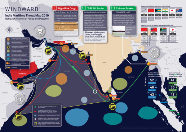
Against this backdrop, comes the first edition of the India Maritime Threat Map. It reveals some of the anomalies found when applying AI-driven, behavioral analysis to vessels, enabling organizations to anticipate threats, and stay ahead of their adversaries. Key findings, include:
Increasing activity by foreign surveillance vessels in the Bay of Bengal.
Large number of vessels crossing the Arabian Sea with armed guards aboard, to protect against piracy.
Prevalence of journeys indicative of illicit activity, such as drug smuggling.
If you like the India Maritime Threat Map, check out our European version, which we published earlier this year. And stay tuned for more threat maps for other parts of the world. For now, stay safe!
Gur Sender is a Pre-Sale Manager at Windward
Download a PDF of the Map
Featured posts
Risks & Compliance
Maritime Global Trade Roundup – April 18, 2024
The Iran attack…Venezuela oil sanctions are back…decreased Russian oil trading…IUU fishing… There was recently some volatility and noteworthy developments, as always. Check out the easily-digestible maritime global trade highlights and trends we are sharing this week, powered by Maritime AI™ insights. Before diving deep, take a look at Windward’s refreshed homepage! The MSC Aries Seizure…
High Stakes on the High Seas: Curbing the Cocaine & Fentanyl Flood
Curbing the Fentanyl flood is a massive challenge for U.S. Customs and Border Protection (CBP) and other law enforcement agencies worldwide. This blog post outlines the challenges, explains why it’s so different from cocaine smuggling, and offers a roadmap forward with four necessary components for stopping the fentanyl flood. Prevalence and Detection Difficulties UCLA-led research…
It was an interesting and somewhat volatile week…as always. Here are the quick highlights and analysis you need from the week in maritime global trade (and sometimes from slightly before this week), powered by Maritime AI™ insights. Also, check out our Windward Trade Patterns & Risk Insights Report for Q1 and Volatility Grows in North…
Windward is excited to participate in next week’s Singapore Maritime Week (SMW) 2024. We’ll be part of the new trade exhibition, Expo@SMW, from April 16-18, which will bring together leading experts to unveil the latest in maritime research and development. This year’s theme, “Actions Meet Ambition,” reflects an emphasis on the maritime sector’s desire to…
The Journey to Success: Celebrating Windward’s 200th Customer Milestone
Windward is proud to announce a significant milestone in our journey: reaching 200 customers. The success we have achieved for and with our ocean freight, trading and shipping, and government customers stems from our ability to provide innovative technology and services that produce AI-powered, actionable insights. Customers choose Windward and then stay with us for...
Webinar: Russia’s Invasion Impact on Maritime Deception and Ecosystem
Windward’s webinar brought together a diverse group of experts to cut through the noise around the impact of Russia’s war on the diverse maritime ecosystem. Exclusive data from Windward’s Maritime AI™ platform, along with insights from the industry-expert guests, enabled the sharing of unique perspectives. The webinar was filled with actionable tactics and ideas that...
Navigating deception: the impact of Russia’s invasion on the maritime ecosystem
Windward’s webinar brought together a diverse group of experts to cut through the noise around the impact of Russia’s war on the diverse maritime ecosystem. Exclusive data from Windward’s Maritime AI™ platform, along with insights from the industry-expert guests, enabled the sharing of unique perspectives. The webinar was filled with actionable tactics and ideas that...
By Irit Singer, Chief Marketing Officer, Windward 2022 was the year that the maritime ecosystem collectively realized that there is simply too much raw data for manual parsing and the landscape changes too rapidly. The world seemed to go crazy: Coronavirus and closures…war, sanctions, and a price cap…new deceptive shipping practices…plummeting ocean freight prices and...